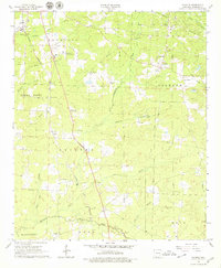
1966 Map of Calhoun
USGS Topo · Published 1979About this map
The Magnolia Oil and Gas Field dominates the landscape of southern Arkansas in the mid-1960s, defined by a complex network of pipelines and industrial sites. The Louisiana and North West railroad cuts a diagonal path through the terrain, serving rural communities like Walker, Kerlin, and Brister. This era reflects a transition between traditional agricultural life and the growing energy sector, with established centers of community like Antioch Ch and St Lukes Ch standing alongside the newer Magnolia Municipal Airport.
Find a feature on this map
40 named features on this map. Tap any name to fly to it.
Don’t see what you’re looking for? This feature index may not catch every label — zoom into the map to look around manually.
Map Details
Editions of this 1966 Calhoun Map
2 editions found
Other maps of this area

1953 · El Dorado
USGS Topo · 1:250,000

1957 · El Dorado
USGS Topo · 1:250,000

1958 · El Dorado
USGS Topo · 1:250,000

1960 · El Dorado
USGS Topo · 1:250,000

1960 · Walkerville
USGS Topo · 1:24,000

1960 · Macedonia
USGS Topo · 1:24,000

1966 · Village
USGS Topo · 1:24,000

1966 · Calhoun
USGS Topo · 1:24,000

1966 · Spotville
USGS Topo · 1:24,000

1968 · Waldo
USGS Topo · 1:24,000