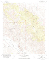
1959 Map of Caliente Mtn
USGS Topo · Published 1976About this map
The Caliente Range dominates this mid-century landscape, a territory defined by high peaks and industrial extraction along the boundary of San Luis Obispo and Santa Barbara counties. Rising to Caliente Mtn, the terrain is punctuated by numerous vital water sources including Black Sulphur Spring, Goat Spring, and Cottonwood Spring. To the southwest, the Cuyama Valley reveals a concentrated energy corridor, where the Russel Ranch Oil Field operates alongside a dedicated Oil Refinery.
Find a feature on this map
28 named features on this map. Tap any name to fly to it.
Don’t see what you’re looking for? This feature index may not catch every label — zoom into the map to look around manually.
Map Details
Editions of this 1959 Caliente Mtn Map
3 editions found
Other maps of this area

1902 · Santa Ynez
USGS Topo · 1:125,000

1905 · Santa Ynez
USGS Topo · 1:125,000

1912 · McKittrick
USGS Topo · 1:125,000

1941 · Caliente Mountain
USGS Topo · 1:62,500

1941 · McPherson Peak
USGS Topo · 1:62,500

1942 · Caliente Mtn
USGS Topo · 1:62,500

1943 · McPherson Peak
USGS Topo · 1:62,500

1943 · Caliente Mtn.
USGS Topo · 1:62,500

1943 · Cuyama Ranch
USGS Topo · 1:31,680

1944 · Panorama Hills
USGS Topo · 1:31,680