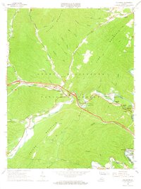
1966 Map of Callaghan
USGS Topo · Published 1967About this map
Peters Mountain and Oliver Mountain dominate the rugged Alleghany County landscape, where the Chesapeake and Ohio railroad corridor follows the winding path of Dunlap Creek. This 1966 field-checked survey highlights the community of Callaghan and the expanding residential areas near Covington, such as Westwood Place and Rayon Terrace. The map provides excellent detail for genealogists and local historians, capturing the placement of several rural houses of worship including Hoke Chapel, Johnsons Creek Ch, and Fletcher Chapel. Civil engineering and early transportation landmarks are notable here, specifically the Mud Tunnel and the Covered Bridge located near the Humpback Bridge Wayside. Industrial footprints are visible at the Lukes Mtn Reservoir and various Industrial Waste Ponds near Oakwood Forest, reflecting the mid-century industrial character of the Jackson River valley.
Find a feature on this map
53 named features on this map. Tap any name to fly to it.
Don’t see what you’re looking for? This feature index may not catch every label — zoom into the map to look around manually.
Map Details
Editions of this 1966 Callaghan Map
2 editions found
Other maps of this area

1887 · Lewisburg
USGS Topo · 1:125,000

1891 · Lewisburg
USGS Topo · 1:125,000

1894 · Natural Bridge
USGS Topo · 1:125,000

1913 · Eagle Rock
USGS Topo · 1:48,000

1915 · Eagle Rock
USGS Topo · 1:62,500

1921 · Callaghan
USGS Topo · 1:48,000

1923 · Callaghan
USGS Topo · 1:62,500

1929 · Falling Spring
USGS Topo · 1:24,000

1932 · Falling Spring
USGS Topo · 1:31,680

1945 · Clifton Forge
USGS Topo · 1:62,500