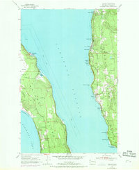
1953 Map of Camano
USGS Topo · Published 1969About this map
Whidbey Island and Camano Island face one another across the deep waters of Saratoga Passage in this mid-century survey. On the western shore, the Whidbey Island Naval Air Station occupies a significant portion of the landscape near Smith Prairie, where Harrington Road and Poggensee Road intersect. This area retains a mix of military utility and rural geography, including the family-named landmark Mathews.
Find a feature on this map
37 named features on this map. Tap any name to fly to it.
Don’t see what you’re looking for? This feature index may not catch every label — zoom into the map to look around manually.
Map Details
Editions of this 1953 Camano Map
4 editions found

Other maps of this area

1911 · Mount Vernon
USGS Topo · 1:125,000

1939 · Coupeville
USGS Topo · 1:62,500

1940 · Mt Vernon
USGS Topo · 1:62,500

1943 · Mt Vernon
USGS Topo · 1:62,500

1943 · Stanwood
USGS Topo · 1:62,500

1943 · Deception Pass
USGS Topo · 1:62,500

1951 · Deception Pass
USGS Topo · 1:62,500

1953 · Coupeville
USGS Topo · 1:24,000

1953 · Freeland
USGS Topo · 1:24,000

1953 · Nordland
USGS Topo · 1:24,000