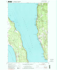
1953 Map of Camano
USGS Topo · Published 1980About this map
Camano Island and Whidbey Island face each other across the deep waters of Saratoga Passage in this mid-century survey. The shoreline of Camano is dotted with coastal settlements and recreational camps, including Indian Beach, Cama Beach, and Camp Grande, reflecting the area's development as a maritime retreat. At the southern end of the sheet, Camano Island State Park preserves the natural shoreline near Saratoga Shores. Across the water on Whidbey Island, the landscape transitions from the coastal Harrington Lagoon to the agricultural and military lands of Smith Prairie, which includes a portion of the Whidbey Island Naval Air Station. Small-scale infrastructure like the Radio Range Sta and Onamac Point Light highlight the era's reliance on localized maritime and aerial navigation aids along Admiralty Inlet.
Find a feature on this map
30 named features on this map. Tap any name to fly to it.
Don’t see what you’re looking for? This feature index may not catch every label — zoom into the map to look around manually.
Map Details
Editions of this 1953 Camano Map
4 editions found

Other maps of this area

1911 · Mount Vernon
USGS Topo · 1:125,000

1939 · Coupeville
USGS Topo · 1:62,500

1940 · Mt Vernon
USGS Topo · 1:62,500

1943 · Mt Vernon
USGS Topo · 1:62,500

1943 · Stanwood
USGS Topo · 1:62,500

1943 · Deception Pass
USGS Topo · 1:62,500

1951 · Deception Pass
USGS Topo · 1:62,500

1953 · Coupeville
USGS Topo · 1:24,000

1953 · Freeland
USGS Topo · 1:24,000

1953 · Nordland
USGS Topo · 1:24,000