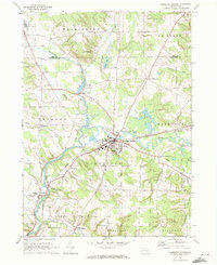
1968 Map of Cambridge Springs
USGS Topo · Published 1972About this map
Cambridge Springs serves as the focal point of this late-1960s landscape, situated at the confluence where French Creek meets numerous tributaries like Little Conneauttee Creek. The map records a transition in local infrastructure, showing the Erie-Lackawanna railroad line alongside an Old Railroad Grade that speaks to earlier transportation corridors. This edition is particularly valuable for its detail of the Alliance College campus and the surrounding cluster of small communities such as Drakes Mills, Skeltontown, and Venango.
Find a feature on this map
42 named features on this map. Tap any name to fly to it.
Don’t see what you’re looking for? This feature index may not catch every label — zoom into the map to look around manually.
Map Details
Editions of this 1968 Cambridge Springs Map
2 editions found
Other maps of this area

1923 · Meadville
USGS Topo · 1:62,500

1923 · Cambridge Springs
USGS Topo · 1:62,500

1925 · Meadville
USGS Topo · 1:62,500

1925 · Cambridge Springs
USGS Topo · 1:62,500

1927 · Townville
USGS Topo · 1:48,000

1929 · Union City
USGS Topo · 1:62,500

1932 · Townville
USGS Topo · 1:62,500

1932 · Union City
USGS Topo · 1:62,500

1943 · Meadville
USGS Topo · 1:62,500

1943 · Cambridge Springs
USGS Topo · 1:62,500