
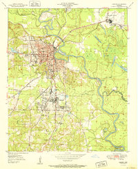
1951 Map of Camden
USGS Topo · Published 1951About this map
The Ouachita River snakes through the heart of this mid-century landscape, anchoring a regional hub defined by timber, transportation, and industrial growth. Camden stands as the primary center, its urban grid supporting essential civic landmarks like the Courthouse, City Hall, and the Water Works. The map illustrates the town’s educational and social infrastructure through several neighborhood institutions, including North Side Sch and Lincoln High Sch, alongside the sprawling Oaklawn Cem.
Find a feature on this map
50 named features on this map. Tap any name to fly to it.
Don’t see what you’re looking for? This feature index may not catch every label — zoom into the map to look around manually.
Map Details
Editions of this 1951 Camden Map
2 editions found
Other maps of this area

1903 · Camden
USGS Topo · 1:125,000

1953 · El Dorado
USGS Topo · 1:250,000

1957 · El Dorado
USGS Topo · 1:250,000

1958 · El Dorado
USGS Topo · 1:250,000

1960 · El Dorado
USGS Topo · 1:250,000

1962 · Louann
USGS Topo · 1:24,000

1962 · Buena Vista
USGS Topo · 1:24,000

1962 · Snow Hill
USGS Topo · 1:24,000

1964 · Smackover
USGS Topo · 1:62,500

1964 · Louann
USGS Topo · 1:62,500