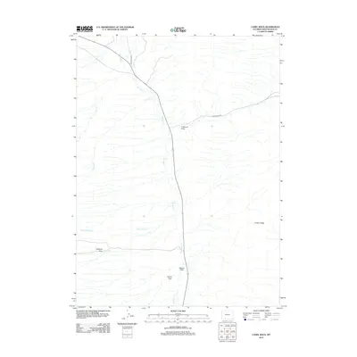
2012 Map of Camel Rock
USGS Topo · Published 2012About this map
Salt Wells Cr serves as the primary drainage axis for this arid portion of Sweetwater County, drawing together numerous seasonal channels in a landscape defined by erosion and isolation. The land's verticality is expressed through names like Camel Rock and the long expanse of Cooper Ridge, while the network of named draws—Cutthroat Draw, Antelope Draw, and Station Draw—suggests a history of local geography defined by where water and travelers once funneled through the terrain. Human presence is sparse, indicated largely by transport corridors like Salt Wells Rd and Brady Field Rd, reflecting the remote character of this region in the early 21st century. The map provides a look at how hydrology dictates nomenclature in the high desert, where even seasonal flows like Snow Spring Cr and Blair Cr are vital landmarks.
Find a feature on this map
11 named features on this map. Tap any name to fly to it.
Don’t see what you’re looking for? This feature index may not catch every label — zoom into the map to look around manually.
Map Details
Editions of this 2012 Camel Rock Map
This is the sole edition of this map. No revisions or reprints were ever made.
Other maps of this area

1908 · Rock Springs
USGS Topo · 1:62,500

1910 · Rock Springs
USGS Topo · 1:62,500

1954 · Rock Springs
USGS Topo · 1:250,000

1958 · Rock Springs
USGS Topo · 1:250,000

1962 · Rock Springs
USGS Topo · 1:250,000

1968 · Cooper Ridge NE
USGS Topo · 1:24,000

1968 · Point Of Rocks SW
USGS Topo · 1:24,000

1968 · Mud Springs Ranch
USGS Topo · 1:24,000
1968 · South Baxter
USGS Topo · 1:24,000

1968 · Camel Rock
USGS Topo · 1:24,000