
1949 Map of Camp Far West
USGS Topo · Published 1986About this map
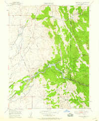
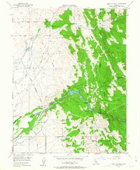
Beale Air Force Base dominates the northern and central portions of this landscape, reflecting the military's significant footprint in the foothills during the mid-20th century. The terrain is defined by the winding course of the Bear River and the expanding waters of the Camp Far West Reservoir, which straddle the border of Yuba and Placer counties. Historical layers are visible throughout, notably at the Camp Far West (Historic Site) and the Spenceville (Site), marking earlier eras of settlement and frontier activity. To the south, the agricultural character of the Thermalands region is evident, supported by a network of ditches and ravines like Fenton Ravine. Traces of the area's industrial past are preserved in the Dairy Farm Mine (Inactive), while local genealogy is represented at the Lofton Cem and the Valley View School near the Rancho Johnson boundary.
Find a feature on this map
26 named features on this map. Tap any name to fly to it.
Don’t see what you’re looking for? This feature index may not catch every label — zoom into the map to look around manually.
Map Details
Editions of this 1949 Camp Far West Map
5 editions found
Historical Maps of Waldo Junction Through Time
50 maps found

1911 Browns Valley
Yuba County, CA

1911 Ostrom
Yuba County, CA

1912 Prairie Creek
Yuba County, CA

1915 Spenceville
Yuba County, CA

1947 Browns Valley
Yuba County, CA

1948 Challenge
Yuba County, CA

1948 French Corral
Yuba County, CA

1948 Oregon House
Yuba County, CA

1948 Strawberry Valley
Yuba County, CA

1949 Browns Valley
Yuba County, CA
1949 Camp Far West
Yuba County, CA

1949 Smartville
Yuba County, CA

1950 Challenge
Yuba County, CA

1950 French Corral
Yuba County, CA

1950 Oregon House
Yuba County, CA

1950 Strawberry Valley
Yuba County, CA

1951 Camp Far West
Yuba County, CA

1951 Smartville
Yuba County, CA

1994 Strawberry Valley
Yuba County, CA

1995 Camp Far West
Yuba County, CA

1995 Challenge
Yuba County, CA

1995 French Corral
Yuba County, CA

1995 Oregon House
Yuba County, CA

1995 Smartville
Yuba County, CA

2000 Challenge
Yuba County, CA

2000 French Corral
Yuba County, CA

2012 Browns Valley
Yuba County, CA

2012 Camp Far West
Yuba County, CA

2012 Challenge
Yuba County, CA

2012 French Corral
Yuba County, CA

2012 Oregon House
Yuba County, CA

2012 Strawberry Valley
Yuba County, CA

2015 Browns Valley
Yuba County, CA

2015 Camp Far West
Yuba County, CA

2015 Challenge
Yuba County, CA

2015 French Corral
Yuba County, CA

2015 Oregon House
Yuba County, CA

2015 Strawberry Valley
Yuba County, CA

2018 Browns Valley
Yuba County, CA

2018 Camp Far West
Yuba County, CA

2018 Challenge
Yuba County, CA

2018 French Corral
Yuba County, CA

2018 Oregon House
Yuba County, CA

2018 Strawberry Valley
Yuba County, CA

2021 Browns Valley
Yuba County, CA

2021 Oregon House
Yuba County, CA

2021 Strawberry Valley
Yuba County, CA

2022 Camp Far West
Yuba County, CA

2022 Challenge
Yuba County, CA

2022 French Corral
Yuba County, CA