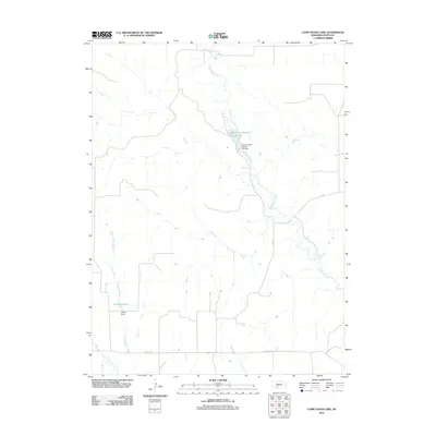
2011 Map of Camp Hayes Lake
USGS Topo · Published 2011About this map
Red Willow Creek defines the central drainage of this Hayes County landscape, flowing south through a terrain marked by small-scale water management and agricultural infrastructure. The most prominent feature is the Hayes Center Special Use Reservoir, secured by the Hayes Center Special Use Dam, which serves as a vital water source in this semi-arid region. Further south, Skunk Creek feeds into the Lelker Reservoir, another man-made impoundment controlled by Lelker Dam. These structures illustrate the modern era's reliance on localized reservoirs to support the surrounding plains. The map also traces the section-line road network, including Road 1470, and shows the headwaters of Little Blackwood Creek in the southwestern corner, providing a clear view of the hydrological and transportation patterns used by local residents.
Find a feature on this map
9 named features on this map. Tap any name to fly to it.
Don’t see what you’re looking for? This feature index may not catch every label — zoom into the map to look around manually.
Map Details
Editions of this 2011 Camp Hayes Lake Map
This is the sole edition of this map. No revisions or reprints were ever made.
Other maps of this area

1954 · McCook
USGS Topo · 1:250,000

1956 · White NE
USGS Topo · 1:24,000

1957 · McCook
USGS Topo · 1:250,000

1958 · McCook
USGS Topo · 1:250,000

1970 · Burger Canyon East
USGS Topo · 1:24,000

1973 · Camp Hayes Lake SE
USGS Topo · 1:24,000

1973 · Suttlers Canyon East
USGS Topo · 1:24,000

1973 · Suttlers Canyon West
USGS Topo · 1:24,000
1973 · Burger Canyon West
USGS Topo · 1:24,000

1974 · Hayes Center
USGS Topo · 1:24,000