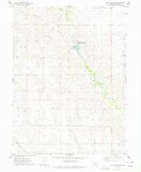
1974 Map of Camp Hayes Lake
USGS Topo · Published 1977About this map
Red Willow Creek meanders through this portion of Hayes County, shaping the drainage patterns of the high plains in the mid-1970s. The landscape is defined by the significant reservoir at Camp Hayes Lake, which is surrounded by the Hayes Center State Special Use Area. This protected territory includes a dedicated Campground on the lake's western shore, serving as a focal point for recreation in an otherwise agrarian and sparsely populated region. The topography is marked by several seasonal and permanent watercourses, including Skunk Creek and Little Blackwood Creek, which cut through the terrain. Erosion has carved distinct features such as Burger Canyon, while localized industry is evidenced by a small Gravel Pit in the southeastern quadrant. This survey reflects the balance of natural resource management and rural land use during this era.
Find a feature on this map
9 named features on this map. Tap any name to fly to it.
Don’t see what you’re looking for? This feature index may not catch every label — zoom into the map to look around manually.
Map Details
Editions of this 1974 Camp Hayes Lake Map
This is the sole edition of this map. No revisions or reprints were ever made.
Other maps of this area

1954 · McCook
USGS Topo · 1:250,000

1956 · White NE
USGS Topo · 1:24,000

1957 · McCook
USGS Topo · 1:250,000

1958 · McCook
USGS Topo · 1:250,000

1970 · Burger Canyon East
USGS Topo · 1:24,000

1973 · Camp Hayes Lake SE
USGS Topo · 1:24,000

1973 · Suttlers Canyon East
USGS Topo · 1:24,000

1973 · Suttlers Canyon West
USGS Topo · 1:24,000
1973 · Burger Canyon West
USGS Topo · 1:24,000

1974 · Hayes Center
USGS Topo · 1:24,000