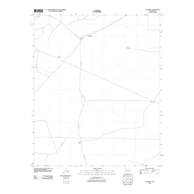
2010 Map of Campbell
USGS Topo · Published 2010About this map
Campbell serves as the focal point for this 2010 survey of the Chaves County plains, where the landscape is defined by extensive ranching operations and water management infrastructure. Named properties such as Sterling Ranch and Graham Ranch anchor the local geography, connected by a network of rural routes including Ponderosa Rd and Mesilla Rd. The essential nature of water in this arid New Mexico environment is evident through the inclusion of functional landmarks like West Windmill, East Windmill, and the White Tank reservoir. To the northwest, the map marks the edge of High Lonesome, a traditional name reflecting the isolated character of the high desert terrain. This map provides researchers and genealogists with a modern record of land use and family-named landmarks in a region where cattle ranching remains the primary economic and social driver.
Find a feature on this map
10 named features on this map. Tap any name to fly to it.
Don’t see what you’re looking for? This feature index may not catch every label — zoom into the map to look around manually.
Map Details
Editions of this 2010 Campbell Map
This is the sole edition of this map. No revisions or reprints were ever made.
Other maps of this area

1949 · Sardine Mountain
USGS Topo · 1:24,000

1949 · L-E Ranch
USGS Topo · 1:24,000

1950 · Comanche Spring
USGS Topo · 1:24,000

1955 · Roswell
USGS Topo · 1:250,000

1958 · Roswell
USGS Topo · 1:250,000

1962 · Roswell
USGS Topo · 1:250,000

1962 · Eightmile Draw
USGS Topo · 1:24,000

1962 · Acme
USGS Topo · 1:24,000
1967 · Campbell
USGS Topo · 1:24,000

1967 · Haystack Mountain
USGS Topo · 1:24,000