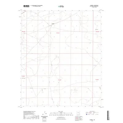
2023 Map of Campbell
USGS Topo · Published 2023About this map
Campbell sits as a central point of interest in this high-desert landscape of Chaves County, where the topography is defined by the elevation of Palma Mesa and the drainage of Lloyds Canyon. The map reveals a structured network of rural access roads, including Magdalena Rd, Mesilla Rd, and Zanes Rd, which crisscross the arid terrain to serve scattered ranching or agricultural sites. A significant man-made water feature, White Tank, highlights the importance of water management in this environment. The land is precisely partitioned by the Public Land Survey System, with township and range lines like t8s r27e and t9s r27e providing the primary framework for property and location within the vast open space of southeastern New Mexico.
Find a feature on this map
15 named features on this map. Tap any name to fly to it.
Don’t see what you’re looking for? This feature index may not catch every label — zoom into the map to look around manually.
Map Details
Editions of this 2023 Campbell Map
This is the sole edition of this map. No revisions or reprints were ever made.
Other maps of this area

1949 · Sardine Mountain
USGS Topo · 1:24,000

1949 · L-E Ranch
USGS Topo · 1:24,000

1950 · Comanche Spring
USGS Topo · 1:24,000

1955 · Roswell
USGS Topo · 1:250,000

1958 · Roswell
USGS Topo · 1:250,000

1962 · Roswell
USGS Topo · 1:250,000

1962 · Eightmile Draw
USGS Topo · 1:24,000

1962 · Acme
USGS Topo · 1:24,000
1967 · Campbell
USGS Topo · 1:24,000

1967 · Haystack Mountain
USGS Topo · 1:24,000