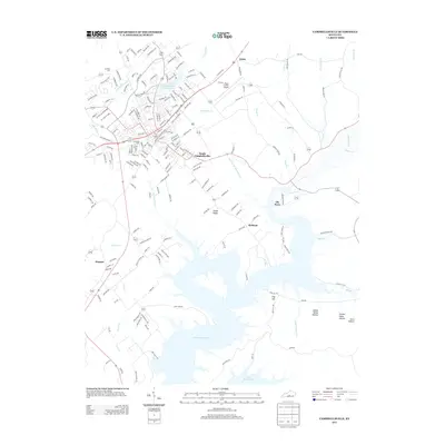
2013 Map of Campbellsville
USGS Topo · Published 2013About this map
Green River Lake dominates the southern landscape, its intricate fingers reaching into the valleys of Meadow Creek and Pinch Creek. This modern survey illustrates the suburban expansion of South Campbellsville and the logistical importance of the Taylor County Airport. The residential layout is dense near the Campbellsville City Reservoir, featuring a network of named streets like N Bypass 3150 and Miller Park Drive. Further from the town center, smaller settlements like Elk Horn, Atchison, and Arista remain connected by rural state routes. Topographical landmarks such as Smith Ridge and Dug Hill overlook the water, while family-oriented sites including Brookside Cemetery and Harding Cemetery offer points of interest for genealogists tracing local heritage. The map effectively documents the transition from a traditional agricultural county seat to a more modernized regional hub with established recreational and transportation infrastructure.
Find a feature on this map
213 named features on this map. Tap any name to fly to it.
Don’t see what you’re looking for? This feature index may not catch every label — zoom into the map to look around manually.
Map Details
Editions of this 2013 Campbellsville Map
This is the sole edition of this map. No revisions or reprints were ever made.
Other maps of this area

1952 · Mannsville
USGS Topo · 1:24,000

1952 · Bradfordsville
USGS Topo · 1:24,000

1953 · Campbellsville
USGS Topo · 1:24,000

1953 · Saloma
USGS Topo · 1:24,000

1953 · Gresham
USGS Topo · 1:24,000

1953 · Spurlington
USGS Topo · 1:24,000

1953 · Cane Valley
USGS Topo · 1:24,000

1953 · Bradfordsville
USGS Topo · 1:24,000

1954 · Knifley
USGS Topo · 1:24,000

1954 · Greensburg
USGS Topo · 1:24,000