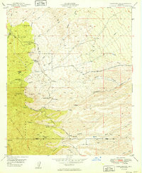
1949 Map of Campo Bonito
USGS Topo · Published 1949About this map
The mining camp of Campo Bonito and several sprawling cattle ranches define this late-1940s landscape on the northeastern slopes of the Santa Catalina Mts. This high-desert terrain is marked by a legacy of mineral extraction, with the Southern Belle Mine, Old Maudina Mine, and Highjinks Mine clustered near the Coronado National Forest boundary. The area's economic life is split between these hard-rock claims and a network of homesteads like the Kannally Ranch, C O D Ranch, and the American Flag Ranch, which sits near American Flag Hill.
Find a feature on this map
34 named features on this map. Tap any name to fly to it.
Don’t see what you’re looking for? This feature index may not catch every label — zoom into the map to look around manually.
Map Details
Editions of this 1949 Campo Bonito Map
2 editions found

Other maps of this area

1904 · Tucson
USGS Topo · 1:125,000

1905 · Tucson
USGS Topo · 1:125,000

1911 · Winkelman
USGS Topo · 1:125,000

1913 · Winkelman
USGS Topo · 1:125,000

1948 · Clark Ranch
USGS Topo · 1:24,000

1948 · Mammoth
USGS Topo · 1:62,500

1948 · Mammoth
USGS Topo · 1:24,000

1948 · Campo Bonito
USGS Topo · 1:24,000

1948 · Peppersauce Wash
USGS Topo · 1:24,000

1949 · Clark Ranch
USGS Topo · 1:24,000