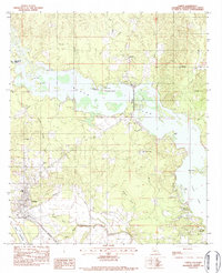
1983 Map of Campti
USGS Topo · Published 1984About this map
The Black Lake basin dominates this northern Louisiana landscape, where intricate water systems like the Weaver Slough and Robeaux Brake create a complex geography of islands and points. In the early 1980s, the community of Campti served as a local hub near the Red River, supported by the Kansas City Southern railroad and proximity to the Oil and Gas Field to the southeast. Local life is anchored by numerous rural congregations, including Our Lady of the Rosary Ch and Westwind Ch. Genealogists may find value in the location of the Campti Cem and the distinct positioning of Old Mount Zion Ch relative to its newer counterpart. The map illustrates a transition from the structured rail corridors near Bourbeaux to the labyrinthine waterways of Clear Lake and Wilmas Slough.
Find a feature on this map
38 named features on this map. Tap any name to fly to it.
Don’t see what you’re looking for? This feature index may not catch every label — zoom into the map to look around manually.
Map Details
Editions of this 1983 Campti Map
2 editions found
Other maps of this area

1937 · Campti NE
USGS Topo · 1:31,680

1937 · Campti SE
USGS Topo · 1:31,680

1937 · Campti NW
USGS Topo · 1:31,680

1937 · Campti SW
USGS Topo · 1:31,680

1944 · Campti
USGS Topo · 1:62,500

1947 · Goldonna
USGS Topo · 1:62,500

1947 · Ashland
USGS Topo · 1:62,500

1948 · Campti
USGS Topo · 1:62,500

1949 · Calvin NW
USGS Topo · 1:31,680

1949 · Calvin SW
USGS Topo · 1:31,680