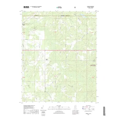
2018 Map of Canaan
USGS Topo · Published 2018About this map
The Wolf River meanders through the heart of this North Mississippi landscape, defining the low-lying Robinson Bottom and the surrounding hills of Benton County. In the north, the community of Michigan City sits near the Tennessee state line, while Spring Hill and Canaan anchor the central and eastern portions of the map. The eastern reaches are largely protected within the Holly Springs National Forest, where smaller tributaries like Blind Tiger Cr and Cypress Br drain the forested terrain. This survey is particularly rich for family history research, documenting numerous burial sites across the countryside such as Valentine Cem, Hill Cem, and Samuel Chapel Cem. The road network, including Hwy 72 and many named local lanes like Hardaway Chapel Rd, reflects a rural settlement pattern where homesteads and small communities are tied closely to the topography and watercourses of the river valley.
Find a feature on this map
73 named features on this map. Tap any name to fly to it.
Don’t see what you’re looking for? This feature index may not catch every label — zoom into the map to look around manually.
Map Details
Editions of this 2018 Canaan Map
This is the sole edition of this map. No revisions or reprints were ever made.
Other maps of this area

1949 · Moscow
USGS Topo · 1:62,500

1950 · Ashland
USGS Topo · 1:62,500

1950 · Grand Junction
USGS Topo · 1:24,000

1951 · Grand Junction
USGS Topo · 1:24,000

1952 · Saulsbury
USGS Topo · 1:24,000

1953 · Holly Springs
USGS Topo · 1:62,500

1956 · Blytheville
USGS Topo · 1:250,000

1956 · Tupelo
USGS Topo · 1:250,000

1958 · Tupelo
USGS Topo · 1:250,000

1959 · Blytheville
USGS Topo · 1:250,000