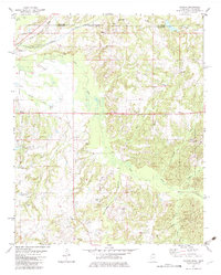
1982 Map of Canaan
USGS Topo · Published 1983About this map
The Wolf River meanders through the heart of this landscape, forming the wide Wolf River Bottom as it flows near the historic border between Tennessee and Mississippi. This rural stretch of Benton County is anchored by the community of Michigan City, where the Illinois Central Gulf railroad tracks cut through the terrain. The eastern portion of the map is dominated by the Holly Springs National Forest, a wooded expanse that includes the settlement of Canaan.
Find a feature on this map
36 named features on this map. Tap any name to fly to it.
Don’t see what you’re looking for? This feature index may not catch every label — zoom into the map to look around manually.
Map Details
Editions of this 1982 Canaan Map
This is the sole edition of this map. No revisions or reprints were ever made.
Other maps of this area

1949 · Moscow
USGS Topo · 1:62,500

1950 · Ashland
USGS Topo · 1:62,500

1950 · Grand Junction
USGS Topo · 1:24,000

1951 · Grand Junction
USGS Topo · 1:24,000

1952 · Saulsbury
USGS Topo · 1:24,000

1953 · Holly Springs
USGS Topo · 1:62,500

1956 · Blytheville
USGS Topo · 1:250,000

1956 · Tupelo
USGS Topo · 1:250,000

1958 · Tupelo
USGS Topo · 1:250,000

1959 · Blytheville
USGS Topo · 1:250,000