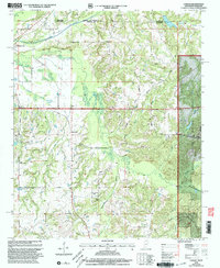
2000 Map of Canaan
USGS Topo · Published 2003About this map
Michigan City sits near the border where the Chickasaw Meridian meets the state line, anchoring a rural landscape defined by the winding course of the Wolf River. This 2000 revision by the USDA Forest Service highlights the extensive reach of the Holly Springs National Forest in the southeastern quadrant, where the terrain shifts toward Robinson Bottom. The map is particularly dense with sites of genealogical interest, preserving the locations of numerous community landmarks like Harris Chapel, Palestine Ch, and Samuels Chapel. The road network transitions from the primary path of Hwy 72 to legacy routes such as Old Road and Pottery Road. Family history is deeply rooted here, evidenced by a high concentration of burial grounds including McKenzie Cem, Littleton Cem, and Robinson Cem, providing a detailed spatial record of the local settlement patterns at the turn of the millennium.
Find a feature on this map
44 named features on this map. Tap any name to fly to it.
Don’t see what you’re looking for? This feature index may not catch every label — zoom into the map to look around manually.
Map Details
Editions of this 2000 Canaan Map
This is the sole edition of this map. No revisions or reprints were ever made.
Other maps of this area

1949 · Moscow
USGS Topo · 1:62,500

1950 · Ashland
USGS Topo · 1:62,500

1950 · Grand Junction
USGS Topo · 1:24,000

1951 · Grand Junction
USGS Topo · 1:24,000

1952 · Saulsbury
USGS Topo · 1:24,000

1953 · Holly Springs
USGS Topo · 1:62,500

1956 · Blytheville
USGS Topo · 1:250,000

1956 · Tupelo
USGS Topo · 1:250,000

1958 · Tupelo
USGS Topo · 1:250,000

1959 · Blytheville
USGS Topo · 1:250,000