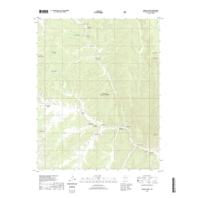
2020 Map of Canada Ojitos
USGS Topo · Published 2020About this map
The Continental Divide runs through this high-elevation landscape in Rio Arriba County, defining a complex network of canyons and seasonal water sources within the Santa Fe National Forest. This modern survey reveals a land primarily utilized for its natural resources and geographic position, highlighted by the remote Murrow Field on the Divide Airport. The terrain is characterized by numerous "cañadas" or small valleys, such as Cañada Ojitos, Cañada Jesus Moya, and Cañada Gurule, which drain into the larger canyon systems. Local ranching or grazing history is evident through features like Pasture Tank, Rodent Tank, and Fence Tank, while natural basins like Laguna Seca and Laguna Simon provide critical water collection points. The deep branching of Spruce Canyon, Boot Jack Canyon, and Horse Heaven Canyon illustrates the intricate drainage patterns that have shaped movement across this part of New Mexico.
Find a feature on this map
36 named features on this map. Tap any name to fly to it.
Don’t see what you’re looking for? This feature index may not catch every label — zoom into the map to look around manually.
Map Details
Editions of this 2020 Canada Ojitos Map
This is the sole edition of this map. No revisions or reprints were ever made.
Other maps of this area

1889 · Largo
USGS Topo · 1:250,000

1895 · Largo
USGS Topo · 1:250,000

1909 · Gallina
USGS Topo · 1:125,000

1954 · Aztec
USGS Topo · 1:250,000

1955 · Llaves
USGS Topo · 1:62,500

1955 · Boulder Lake
USGS Topo · 1:62,500

1958 · Aztec
USGS Topo · 1:250,000

1962 · Aztec
USGS Topo · 1:250,000

1963 · Lindrith
USGS Topo · 1:24,000
1963 · Ojito
USGS Topo · 1:24,000