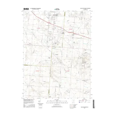
2016 Map of Canal Winchester
USGS Topo · Published 2016About this map
Canal Winchester serves as a focal point for this region where the suburban expansion of Columbus meets the established rural landscapes of Franklin, Fairfield, and Pickaway counties. The map highlights a significant concentration of commemorative and civic sites, ranging from the Arlington Burial Park and Union Grove Cem in the north to the Glick Brick Church and Marcy Cem further south. Notable architectural preservation is evident in the inclusion of the Bergstresser Covered Bridge and Loucks Covered Bridge, which cross Walnut Creek, a waterway that defines much of the local topography alongside tributaries like Wild Violet Run and Running Root Run. To the east, the rising terrain of Chestnut Ridge leads into the Chestnut Ridge Slough, illustrating the transition from the flatlands toward more varied elevations. This record of the 2010s captures the area's mix of modern residential developments and deep-rooted landmarks like the Mennonite Church-Cem.
Find a feature on this map
119 named features on this map. Tap any name to fly to it.
Don’t see what you’re looking for? This feature index may not catch every label — zoom into the map to look around manually.
Map Details
Editions of this 2016 Canal Winchester Map
This is the sole edition of this map. No revisions or reprints were ever made.
Other maps of this area

1907 · Lancaster
USGS Topo · 1:62,500

1907 · Thurston
USGS Topo · 1:62,500

1909 · Lancaster
USGS Topo · 1:62,500

1909 · Thurston
USGS Topo · 1:62,500

1914 · Circleville
USGS Topo · 1:62,500

1925 · East Columbus
USGS Topo · 1:62,500

1943 · Circleville
USGS Topo · 1:62,500

1943 · East Columbus
USGS Topo · 1:62,500

1947 · Columbus
USGS Topo · 1:250,000
1955 · Lockbourne
USGS Topo · 1:24,000