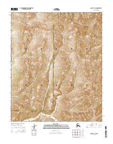
2015 Map of Candle B-1 SW
USGS Topo · Published 2015About this map
The Continental Divide defines the northern reaches of this remote landscape, marking the hydrological boundary between the vast interior watersheds and the western drainage systems. Below these high ridgelines, the Inglutalik River serves as the primary drainage, meandering southward through a series of valleys as it crosses the boundary between the Nome Census Area and the Yukon-Koyukuk Census Area. The survey highlights the transition from upland divides to the winding river bottom, where the water path dictates the natural travel corridors through the region. Land use here remains defined by large-scale public land survey system blocks, including t1s r4w, t2s r4w, and t3s r4w, which delineate the territory without the presence of permanent settlements or infrastructure.
Find a feature on this map
9 named features on this map. Tap any name to fly to it.
Don’t see what you’re looking for? This feature index may not catch every label — zoom into the map to look around manually.
Map Details
Editions of this 2015 Candle B-1 SW Map
This is the sole edition of this map. No revisions or reprints were ever made.
Other maps of this area

1951 · Candle
USGS Topo · 1:250,000

1954 · Candle A-2
USGS Topo · 1:63,360

1954 · Candle A-1
USGS Topo · 1:63,360

1954 · Candle B-2
USGS Topo · 1:63,360

1954 · Candle B-1
USGS Topo · 1:63,360

1955 · Candle
USGS Topo · 1:250,000

1955 · Candle A-2
USGS Topo · 1:63,360

1964 · Candle
USGS Topo · 1:250,000
2015 · Candle B-2 SE
USGS Topo · 1:25,000
2015 · Candle B-1 SE
USGS Topo · 1:25,000