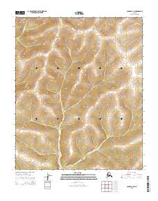
2015 Map of Candle B-3 SE
USGS Topo · Published 2015About this map
The Continental Divide defines the northern reaches of this landscape, separating the drainage systems in a region of the Seward Peninsula defined by its high-latitude watercourses. The Nigikmigoon River flows prominently through the central and southern portions of the map, carving a path through the terrain as it heads toward its eventual confluence. To the northwest, the headwaters of the E Fork Koyuk River begin their descent, while Kilusiktok Cr marks the northeastern corner. This 2015 survey, published by the U.S. Geological Survey, illustrates the complex hydrologic network of this remote interior, where the primary geographical markers are the named rivers and the significant topographical barrier of the divide itself.
Find a feature on this map
10 named features on this map. Tap any name to fly to it.
Don’t see what you’re looking for? This feature index may not catch every label — zoom into the map to look around manually.
Map Details
Editions of this 2015 Candle B-3 SE Map
This is the sole edition of this map. No revisions or reprints were ever made.
Other maps of this area

1951 · Candle
USGS Topo · 1:250,000

1954 · Candle A-2
USGS Topo · 1:63,360

1954 · Candle B-2
USGS Topo · 1:63,360

1955 · Candle
USGS Topo · 1:250,000

1955 · Candle B-3
USGS Topo · 1:63,360

1955 · Candle A-2
USGS Topo · 1:63,360

1964 · Candle
USGS Topo · 1:250,000
2014 · Candle B-3 NW
USGS Topo · 1:25,000
2014 · Candle A-3 NE
USGS Topo · 1:25,000
2014 · Candle A-3 NW
USGS Topo · 1:25,000