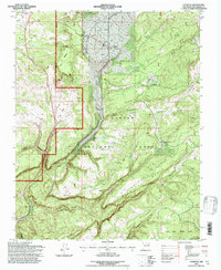
1995 Map of Canjilon
USGS Topo · Published 1997About this map
Canjilon sits at the heart of this high-elevation landscape, surrounded by the intricate drainage systems of the Carson National Forest. This 1995 revision reveals a traditional rural settlement pattern centered on the waters of Canjilon Creek, with small clusters of development at Placita Garcia and Llanito de la Cruz. The terrain is characterized by a series of distinct plateaus and deep incisions, notably Domingo Mesa and Navajo Canyon.
Find a feature on this map
48 named features on this map. Tap any name to fly to it.
Don’t see what you’re looking for? This feature index may not catch every label — zoom into the map to look around manually.
Map Details
Editions of this 1995 Canjilon Map
This is the sole edition of this map. No revisions or reprints were ever made.
Other maps of this area

1909 · Gallina
USGS Topo · 1:125,000

1918 · Abiquiu
USGS Topo · 1:125,000

1918 · Tusas
USGS Topo · 1:125,000

1953 · Alire
USGS Topo · 1:24,000

1953 · Echo Ampitheater
USGS Topo · 1:24,000

1953 · Magote Peak
USGS Topo · 1:24,000

1953 · Canjilon
USGS Topo · 1:24,000

1953 · Canjilon SE
USGS Topo · 1:24,000

1953 · Ghost Ranch
USGS Topo · 1:24,000

1954 · Aztec
USGS Topo · 1:250,000