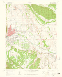
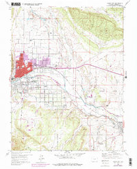
1959 Map of Canon City
USGS Topo · Published 1961About this map
The Arkansas River corridor defines this mid-century landscape of Fremont County, where industrial operations and civic institutions cluster along the valley floor. Canon City serves as the primary hub, surrounded by a network of smaller residential pockets like Lincoln Park and Orchard Park. The map documents a complex irrigation and transport infrastructure, featuring the Park Center Ditch and the Hydraulic Ditch alongside the competing lines of the Denver and Rio Grande Western Railroad and the Atchison Topeka and Santa Fe Railroad. Of particular historical interest is the large State Prison Farm to the east and the dramatic Skyline Drive following the hogback ridge to the west. From the Abbey Sch to the Brick Kilns, the sheet captures a mix of educational, religious, and industrial sites essential for local history and genealogical research.
Find a feature on this map
79 named features on this map. Tap any name to fly to it.
Don’t see what you’re looking for? This feature index may not catch every label — zoom into the map to look around manually.
Map Details
Editions of this 1959 Canon City Map
5 editions found
Other maps of this area

1889 · Canon City
USGS Topo · 1:125,000

1892 · Canon City
USGS Topo · 1:125,000

1894 · Pikes Peak
USGS Topo · 1:125,000

1901 · Pikes Peak
USGS Topo · 1:125,000

1942 · Cover Mtn.
USGS Topo · 1:62,500

1948 · Cover Mtn.
USGS Topo · 1:62,500

1954 · Phantom Canyon
USGS Topo · 1:24,000

1954 · Cooper Mountain
USGS Topo · 1:24,000

1954 · Pueblo
USGS Topo · 1:250,000

1957 · Pueblo
USGS Topo · 1:250,000