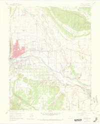
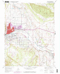
1959 Map of Canon City
USGS Topo · Published 1968About this map
Canon City and the surrounding industrial corridor of the Arkansas River valley appear in detail on this 1959 field-checked sheet. The landscape is defined by the complex infrastructure of the era, from the sprawling State Prison Farm to the intricate network of water management features like the Minnequa Dam and Sell Lake. Small coal-mining and labor settlements such as Brookside, Rockvale, and Williamsburg sit south of the river, while the rail-dependent economy of Florence anchors the southeast corner. Transportation history is prominent through the heavy presence of the Denver and Rio Grande Western and the Atchison Topeka and Santa Fe railroads, alongside remnants of older transit like the Santa Fe Grade. Educational and religious landmarks including the Abbey School and McKinley School provide key geographic markers for genealogists tracing mid-century community life.
Find a feature on this map
51 named features on this map. Tap any name to fly to it.
Don’t see what you’re looking for? This feature index may not catch every label — zoom into the map to look around manually.
Map Details
Editions of this 1959 Canon City Map
5 editions found
Other maps of this area

1889 · Canon City
USGS Topo · 1:125,000

1892 · Canon City
USGS Topo · 1:125,000

1894 · Pikes Peak
USGS Topo · 1:125,000

1901 · Pikes Peak
USGS Topo · 1:125,000

1942 · Cover Mtn.
USGS Topo · 1:62,500

1948 · Cover Mtn.
USGS Topo · 1:62,500

1954 · Phantom Canyon
USGS Topo · 1:24,000

1954 · Cooper Mountain
USGS Topo · 1:24,000

1954 · Pueblo
USGS Topo · 1:250,000

1957 · Pueblo
USGS Topo · 1:250,000