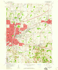
1958 Map of Canton East
USGS Topo · Published 1960About this map
Industrial and educational hubs define the eastern edge of Canton during the late 1950s. The landscape is heavily marked by the intersections of major transit corridors like the Lincoln Highway and the Nickel Plate Road, which serve the dense residential and industrial pockets of Louisville and East Canton. This survey illustrates a period of significant civic investment, evidenced by the high density of neighborhood schools such as McKinley High Sch and Township High Sch, along with several parochial institutions like St Anthonys Sch.
Find a feature on this map
79 named features on this map. Tap any name to fly to it.
Don’t see what you’re looking for? This feature index may not catch every label — zoom into the map to look around manually.
Map Details
Editions of this 1958 Canton East Map
This is the sole edition of this map. No revisions or reprints were ever made.
Other maps of this area

1901 · Canton
USGS Topo · 1:62,500

1903 · Canton
USGS Topo · 1:62,500

1909 · Alliance
USGS Topo · 1:62,500

1910 · Carrollton
USGS Topo · 1:62,500

1912 · Dover
USGS Topo · 1:62,500

1912 · Carrollton
USGS Topo · 1:62,500

1944 · Dover
USGS Topo · 1:62,500

1951 · Canton
USGS Topo · 1:250,000

1951 · Bolivar
USGS Topo · 1:24,000

1953 · Canton
USGS Topo · 1:250,000