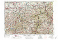
1957 Map of Canton
USGS Topo · Published 1978About this map
The Ohio River and its industrial corridors define this mid-century portrait of the tri-state region. This survey captures the dense network of steel towns and rail hubs as they appeared following the post-war industrial peak. Major urban centers like Canton, Akron, and Pittsburgh are shown alongside the sprawling infrastructure of the Pennsylvania RR and the Baltimore & Ohio RR, reflecting the heavy reliance on rail transport for coal and manufacturing.
Find a feature on this map
103 named features on this map. Tap any name to fly to it.
Don’t see what you’re looking for? This feature index may not catch every label — zoom into the map to look around manually.
Map Details
Editions of this 1957 Canton Map
3 editions found

Other maps of this area

1900 · Masontown
USGS Topo · 1:62,500

1901 · Cadiz
USGS Topo · 1:62,500

1901 · Massillon
USGS Topo · 1:62,500

1901 · Amity
USGS Topo · 1:62,500

1901 · Canton
USGS Topo · 1:62,500

1901 · Waynesburg
USGS Topo · 1:62,500

1901 · Beaver
USGS Topo · 1:62,500

1901 · Wooster
USGS Topo · 1:62,500

1902 · Wheeling
USGS Topo · 1:62,500

1902 · Brownsville
USGS Topo · 1:62,500