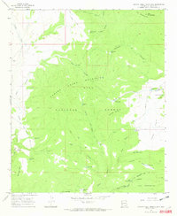
1965 Map of Canyon Creek Mountains
USGS Topo · Published 1970About this map
The Canyon Creek Mountains define the heart of this high-elevation landscape within the Gila National Forest. This mid-1960s survey captures a transition in land use where the northern reaches of the Gila Wilderness meet isolated outposts of ranching life. The presence of Hulse Ranch near Canyon Creek and Double Springs Ranch to the south suggests the enduring necessity of water management in this arid terrain, a fact reinforced by the high density of catchment tanks like Upper Cooney Tank and Stovepipe Tank.
Find a feature on this map
50 named features on this map. Tap any name to fly to it.
Don’t see what you’re looking for? This feature index may not catch every label — zoom into the map to look around manually.
Map Details
Editions of this 1965 Canyon Creek Mountains Map
2 editions found
Other maps of this area

1911 · Alum Mountain
USGS Topo · 1:125,000

1913 · Alum Mountain
USGS Topo · 1:125,000

1918 · Pelona
USGS Topo · 1:125,000

1954 · Clifton
USGS Topo · 1:250,000

1957 · Clifton
USGS Topo · 1:250,000

1958 · Clifton
USGS Topo · 1:250,000

1962 · Clifton
USGS Topo · 1:250,000
1963 · Loco Mountain
USGS Topo · 1:24,000
1963 · Pitchfork Canyon
USGS Topo · 1:24,000
1965 · Canyon Creek Mountains
USGS Topo · 1:24,000