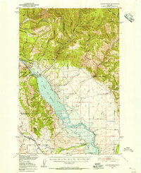
1950 Map of Canyon Ferry
USGS Topo · Published 1956About this map
The Missouri River corridor undergoes a major transformation on this mid-century survey, which documents the proposed Lake Sewell Reservoir area at the boundary of Lewis and Clark and Broadwater Counties. The map captures a landscape in transition as the New Canyon Ferry Dam is sited near the original Canyon Ferry Dam, an engineering shift that would eventually alter the valley floor. To the east, the Big Belt Mountains rise sharply, dissected by numerous drainages like Hellgate Gulch and Avalanche Gulch. Historic mining activity is evident at the Argo Mine and various unnamed mine shafts near the settlement of York. In the southern reaches, the Spokane Ditch and the Northern Pacific railroad line skirt the Spokane Hills, serving the agricultural and industrial needs of the region during this era of federal river basin development.
Find a feature on this map
66 named features on this map. Tap any name to fly to it.
Don’t see what you’re looking for? This feature index may not catch every label — zoom into the map to look around manually.
Map Details
Editions of this 1950 Canyon Ferry Map
3 editions found
Other maps of this area

1886 · Fort Logan
USGS Topo · 1:250,000

1948 · White Sulphur Springs
USGS Topo · 1:250,000

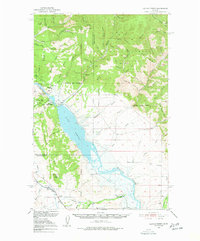
1950 · Canyon Ferry
USGS Topo · 1:62,500

1950 · Townsend
USGS Topo · 1:62,500

1950 · Duck Creek Pass
USGS Topo · 1:62,500

1950 · East Helena
USGS Topo · 1:62,500

1950 · Clancy
USGS Topo · 1:62,500

1958 · White Sulphur Springs
USGS Topo · 1:250,000

1961 · White Sulphur Springs
USGS Topo · 1:250,000

1962 · Hogback Mountain
USGS Topo · 1:24,000