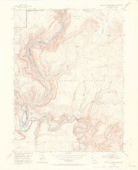
1954 Map of Canyon Of Lodore South
USGS Topo · Published 1969About this map
Dinosaur National Monument defines this mid-century landscape where the Green River and Yampa River meet in a dramatic canyon system. The confluence at Echo Park (Pats Hole) is the central geographic focus, framed by massive formations like Steamboat Rock and Jenny Lind Rock. The map records a transition from early pioneer activity to federal land management, noted by the presence of Massey Cabin (Aband) and Buffham Place.
Find a feature on this map
31 named features on this map. Tap any name to fly to it.
Don’t see what you’re looking for? This feature index may not catch every label — zoom into the map to look around manually.
Map Details
Editions of this 1954 Canyon Of Lodore South Map
5 editions found
Other maps of this area

1885 · Ashley
USGS Topo · 1:250,000

1907 · Rangely
USGS Topo · 1:125,000

1907 · Jensen
USGS Topo · 1:125,000

1910 · Jensen
USGS Topo · 1:125,000

1910 · Rangely
USGS Topo · 1:125,000

1954 · Hells Canyon
USGS Topo · 1:24,000

1954 · Canyon of Lodore South
USGS Topo · 1:24,000

1954 · Canyon of Lodore North
USGS Topo · 1:24,000

1954 · Vernal
USGS Topo · 1:250,000

1955 · Stuntz Reservoir
USGS Topo · 1:24,000