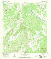
1967 Map of Cap Mountain
USGS Topo · Published 1970About this map
The Llano River cuts a deep path through the granite and limestone of Llano County, framing a landscape defined by the Riley Mountains and distinctive peaks like Cap Mountain and Dancer Peak. In the late 1960s, this area remained largely rural, centered around the Duncan Community Center and the settlement of Gainesville. The presence of numerous family and community burial grounds, such as Cap Mountain Cem and Paschall Cem, indicates a deeply rooted local history tied to the land's rugged topography.
Find a feature on this map
35 named features on this map. Tap any name to fly to it.
Don’t see what you’re looking for? This feature index may not catch every label — zoom into the map to look around manually.
Map Details
Editions of this 1967 Cap Mountain Map
This is the sole edition of this map. No revisions or reprints were ever made.
Other maps of this area

1887 · Llano
USGS Topo · 1:125,000

1887 · Burnet
USGS Topo · 1:125,000

1893 · Burnet
USGS Topo · 1:125,000

1894 · Llano
USGS Topo · 1:125,000

1903 · Burnet
USGS Topo · 1:125,000

1904 · Llano
USGS Topo · 1:125,000

1909 · Llano
USGS Topo · 1:125,000

1909 · Burnet
USGS Topo · 1:125,000

1918 · Llano
USGS Topo · 1:125,000

1925 · Burnet 3-b
USGS Topo · 1:48,000