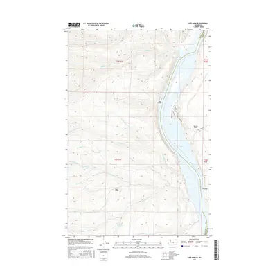
2017 Map of Cape Horn SE
USGS Topo · Published 2017About this map
Columbia River frontage and the expansive waters of Wanapum Lake dominate the eastern boundary of this Kittitas County landscape. The terrain is defined by dramatic elevation shifts, where the high desert plateau breaks into steep-walled landforms like Box Canyon and the prominent Babcock Bench. Multiple seasonal drainage systems, including Quilomene Cr and the north and south forks of Skookumchuck Cr, have carved deep coulees through the basalt as they descend toward the river valley.
Find a feature on this map
33 named features on this map. Tap any name to fly to it.
Don’t see what you’re looking for? This feature index may not catch every label — zoom into the map to look around manually.
Map Details
Editions of this 2017 Cape Horn SE Map
This is the sole edition of this map. No revisions or reprints were ever made.
Other maps of this area

1909 · Quincy
USGS Topo · 1:62,500

1910 · Quincy
USGS Topo · 1:62,500

1912 · Beverly
USGS Topo · 1:62,500

1920 · Colockum Pass
USGS Topo · 1:125,000

1922 · Colockum Pass
USGS Topo · 1:125,000

1939 · Boylston
USGS Topo · 1:48,000

1943 · Boylston
USGS Topo · 1:62,500

1950 · Yakima
USGS Topo · 1:250,000

1953 · Ginkgo
USGS Topo · 1:24,000
1953 · Boylston
USGS Topo · 1:24,000