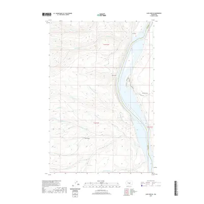
2020 Map of Cape Horn SE
USGS Topo · Published 2020About this map
Wanapum Lake dominates the eastern edge of this landscape, carving through the high desert of Central Washington along the Kittitas and Grant county line. The steep basalt terrain is defined by dramatic elevation changes, notably at Babcock Bench and the narrow passage of Box Canyon. A complex network of drainages including Quilomene Cr, Skookumchuck Cr, and Whiskey-Dick Cr flows eastward toward the reservoir, reflecting a classic Columbia Basin watershed pattern. On the western shore of the lake, a small cluster of residential roads such as Sunland Rd and River Dr Sw suggests a localized riverside community. Higher in the western hills, isolated water sources like Bohinkleman Spring and Kohler Spring mark the few reliable points in an otherwise arid environment characterized by features like Patte Canyon and Dry Gulch.
Find a feature on this map
30 named features on this map. Tap any name to fly to it.
Don’t see what you’re looking for? This feature index may not catch every label — zoom into the map to look around manually.
Map Details
Editions of this 2020 Cape Horn SE Map
This is the sole edition of this map. No revisions or reprints were ever made.
Other maps of this area

1909 · Quincy
USGS Topo · 1:62,500

1910 · Quincy
USGS Topo · 1:62,500

1912 · Beverly
USGS Topo · 1:62,500

1920 · Colockum Pass
USGS Topo · 1:125,000

1922 · Colockum Pass
USGS Topo · 1:125,000

1939 · Boylston
USGS Topo · 1:48,000

1943 · Boylston
USGS Topo · 1:62,500

1950 · Yakima
USGS Topo · 1:250,000

1953 · Ginkgo
USGS Topo · 1:24,000
1953 · Boylston
USGS Topo · 1:24,000