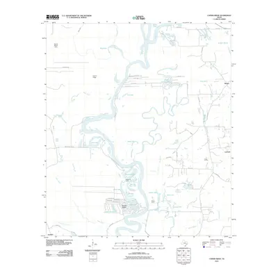
2010 Map of Capers Ridge
USGS Topo · Published 2010About this map
The Trinity River snakes through a dense network of oxbow lakes and wetlands in this part of Liberty County. Small communities and named landings like Dayton Lakes and Morris Camp are situated along the river's winding course, where the water has carved out a complex system of bayous and marshes. The map reveals the hydrology of the Texas Gulf Coast, characterized by features such as New Old River Lake, Rosewood Lake, and Pecan Lake, which are remnants of the river's changing path. Away from the water's edge, Capers Ridge and Prairie Marsh Gully define the local topography.
Find a feature on this map
60 named features on this map. Tap any name to fly to it.
Don’t see what you’re looking for? This feature index may not catch every label — zoom into the map to look around manually.
Map Details
Editions of this 2010 Capers Ridge Map
This is the sole edition of this map. No revisions or reprints were ever made.
Other maps of this area

1943 · Liberty
USGS Topo · 1:125,000

1954 · Beaumont
USGS Topo · 1:250,000

1955 · Daisetta
USGS Topo · 1:62,500

1955 · Saratoga
USGS Topo · 1:62,500

1955 · Rayburn
USGS Topo · 1:62,500

1955 · Liberty
USGS Topo · 1:62,500

1957 · Beaumont
USGS Topo · 1:250,000

1984 · Beaumont
USGS Topo · 1:250,000
1984 · Arizona Creek
USGS Topo · 1:24,000
1984 · Dayton
USGS Topo · 1:24,000