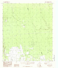
1984 Map of Arizona Creek
USGS Topo · Published 1985About this map
Big Thicket National Preserve occupies a significant portion of this landscape, marking a transition between the dense hardwood forests and the water-heavy terrain of the Texas Gulf Coast. The map records the meandering courses of Arizona Creek and Pine Island Bayou as they define the boundary between Hardin and Liberty counties. This environment is characterized by an intricate network of waterways, including Black Land Slough, Mayhaw Slough, and Tanner Bayou, which illustrate the complex drainage patterns of the region. Human presence is concentrated near the settlement of Batiste, while the wider terrain shows scattered oil wells, reflecting the local intersection of conservation efforts and energy extraction during the mid-1970s and early 1980s. The dense forest canopy and swampy bottoms remain relatively undeveloped, preserving the character of the Big Thicket.
Find a feature on this map
13 named features on this map. Tap any name to fly to it.
Don’t see what you’re looking for? This feature index may not catch every label — zoom into the map to look around manually.
Map Details
Editions of this 1984 Arizona Creek Map
This is the sole edition of this map. No revisions or reprints were ever made.
Other maps of this area

1943 · Liberty
USGS Topo · 1:125,000

1954 · Beaumont
USGS Topo · 1:250,000

1955 · Daisetta
USGS Topo · 1:62,500

1955 · Saratoga
USGS Topo · 1:62,500

1955 · Rayburn
USGS Topo · 1:62,500

1955 · Liberty
USGS Topo · 1:62,500

1957 · Beaumont
USGS Topo · 1:250,000

1984 · Beaumont
USGS Topo · 1:250,000
1984 · Saratoga
USGS Topo · 1:24,000
1984 · Hardin
USGS Topo · 1:24,000