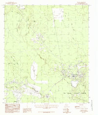
1984 Map of Saratoga
USGS Topo · Published 1985About this map
Saratoga and Batson anchor this mid-1980s landscape in Hardin County, where the dense woodlands of the Big Thicket National Preserve dominate the terrain. This survey illustrates the intricate drainage systems that define the region, including the winding paths of Pine Island Bayou and Little Pine Island Bayou. The prominence of an active Oil Field and numerous pipelines indicates the persistent industrial influence on the local economy. In contrast to the developed corridors, the map reveals a network of low-lying water features such as Shinglemill Slough, Mayhaw Slough, and Black Land Slough, which cut through the thicket. Historic landmarks like the Lookout Tower near the center of the sheet and a Roadside Park along the southern road emphasize the balance between resource extraction and public land preservation in this part of Southeast Texas.
Find a feature on this map
19 named features on this map. Tap any name to fly to it.
Don’t see what you’re looking for? This feature index may not catch every label — zoom into the map to look around manually.
Map Details
Editions of this 1984 Saratoga Map
This is the sole edition of this map. No revisions or reprints were ever made.
Other maps of this area

1943 · Liberty
USGS Topo · 1:125,000

1954 · Beaumont
USGS Topo · 1:250,000

1955 · Daisetta
USGS Topo · 1:62,500

1955 · Saratoga
USGS Topo · 1:62,500

1955 · Kountze
USGS Topo · 1:62,500

1955 · Sour Lake
USGS Topo · 1:62,500

1957 · Beaumont
USGS Topo · 1:250,000

1984 · Beaumont
USGS Topo · 1:250,000

1984 · Sour Lake
USGS Topo · 1:24,000
1984 · Arizona Creek
USGS Topo · 1:24,000