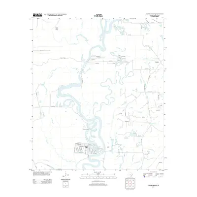
2013 Map of Capers Ridge
USGS Topo · Published 2013About this map
The Trinity River snakes through a dense network of bayous and oxbow lakes in this 2013 study of the Liberty County bottomlands. This riparian landscape is defined by the shifting waters of Gillen Bayou, Greens Bayou, and McMurtry Bayou, which carve through the low-lying terrain surrounding Capers Ridge. To the east, the industrial imprint of the Hardin Oil Field sits adjacent to the Lakeland community, showing the intersection of local resource extraction and rural settlement.
Find a feature on this map
83 named features on this map. Tap any name to fly to it.
Don’t see what you’re looking for? This feature index may not catch every label — zoom into the map to look around manually.
Map Details
Editions of this 2013 Capers Ridge Map
This is the sole edition of this map. No revisions or reprints were ever made.
Other maps of this area

1943 · Liberty
USGS Topo · 1:125,000

1954 · Beaumont
USGS Topo · 1:250,000

1955 · Daisetta
USGS Topo · 1:62,500

1955 · Saratoga
USGS Topo · 1:62,500

1955 · Rayburn
USGS Topo · 1:62,500

1955 · Liberty
USGS Topo · 1:62,500

1957 · Beaumont
USGS Topo · 1:250,000

1984 · Beaumont
USGS Topo · 1:250,000
1984 · Arizona Creek
USGS Topo · 1:24,000
1984 · Dayton
USGS Topo · 1:24,000