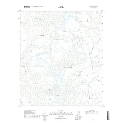
2019 Map of Capers Ridge
USGS Topo · Published 2019About this map
The Trinity River dominates this landscape in Liberty County, carving a wide, serpentine path through an intricate network of wetlands and oxbow lakes. The small residential development of Dayton-Lakes sits on the river’s western bank, with streets like Nueces Dr and Trinity Rd providing a rare pocket of settlement amidst the dense hydrography. The area is defined by a complex system of waterways, including the winding Gillen Bayou, McMurtry Bayou, and Greens Bayou, which feed into various bodies of water such as Fitz Lake, Otter Lake, and Sand Lake.
Find a feature on this map
70 named features on this map. Tap any name to fly to it.
Don’t see what you’re looking for? This feature index may not catch every label — zoom into the map to look around manually.
Map Details
Editions of this 2019 Capers Ridge Map
This is the sole edition of this map. No revisions or reprints were ever made.
Other maps of this area

1943 · Liberty
USGS Topo · 1:125,000

1954 · Beaumont
USGS Topo · 1:250,000

1955 · Daisetta
USGS Topo · 1:62,500

1955 · Saratoga
USGS Topo · 1:62,500

1955 · Rayburn
USGS Topo · 1:62,500

1955 · Liberty
USGS Topo · 1:62,500

1957 · Beaumont
USGS Topo · 1:250,000

1984 · Beaumont
USGS Topo · 1:250,000
1984 · Arizona Creek
USGS Topo · 1:24,000
1984 · Dayton
USGS Topo · 1:24,000