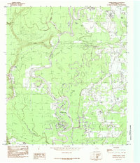
1984 Map of Capers Ridge
USGS Topo · Published 1986About this map
The meandering Trinity River dominates this mid-1970s landscape on the border of Liberty and Texas counties, creating a complex network of oxbows and wetlands. Notable water bodies such as New Old River Lake, Rosewood Lake, and Alcorn Lake highlight the shifting course of the river over time. The terrain is defined by the elevated Capers Ridge, which overlooks a dense collection of bayous including Gillen Bayou and Greens Bayou.
Find a feature on this map
30 named features on this map. Tap any name to fly to it.
Don’t see what you’re looking for? This feature index may not catch every label — zoom into the map to look around manually.
Map Details
Editions of this 1984 Capers Ridge Map
This is the sole edition of this map. No revisions or reprints were ever made.
Other maps of this area

1943 · Liberty
USGS Topo · 1:125,000

1954 · Beaumont
USGS Topo · 1:250,000

1955 · Daisetta
USGS Topo · 1:62,500

1955 · Saratoga
USGS Topo · 1:62,500

1955 · Rayburn
USGS Topo · 1:62,500

1955 · Liberty
USGS Topo · 1:62,500

1957 · Beaumont
USGS Topo · 1:250,000

1984 · Beaumont
USGS Topo · 1:250,000
1984 · Arizona Creek
USGS Topo · 1:24,000
1984 · Dayton
USGS Topo · 1:24,000