
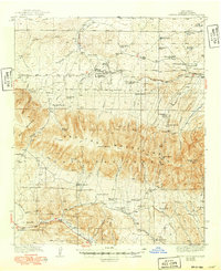
1940 Map of Capitan Mountains
USGS Topo · Published 1940About this map
The Capitan Mountains rise sharply over Lincoln County, defining a landscape of isolated ranching outposts and government conservation efforts in the mid-1930s. This survey records a network of family-held properties such as the Merchant Ranch, Padilla Ranch, and Shoemaker Ranch scattered among the high ridges and deep canyons. The presence of the Lookout Block Ranger Sta and the Richardson Sch indicates the dual priorities of forestry management and rural education during this era.
Find a feature on this map
61 named features on this map. Tap any name to fly to it.
Don’t see what you’re looking for? This feature index may not catch every label — zoom into the map to look around manually.
Map Details
Editions of this 1940 Capitan Mountains Map
2 editions found
Other maps of this area

1934 · Capitan
USGS Topo · 1:48,000

1935 · Capitan Mountains
USGS Topo · 1:48,000

1936 · Arabela
USGS Topo · 1:48,000

1937 · Capitan
USGS Topo · 1:62,500

1942 · Arabela
USGS Topo · 1:62,500

1955 · Roswell
USGS Topo · 1:250,000

1958 · Roswell
USGS Topo · 1:250,000

1961 · Lincoln
USGS Topo · 1:62,500

1961 · Tinnie
USGS Topo · 1:62,500

1962 · Roswell
USGS Topo · 1:250,000