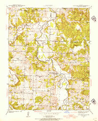
1939 Map of Caplinger Mills
USGS Topo · Published 1954About this map
Caplinger Mills sits along the winding course of the Sac River, serving as a central hub in this 1939 survey of Cedar County. The landscape is defined by the river’s dramatic geography, featuring Horseshoe Bend and several named islands such as Masters Island and Keith Island. Numerous rural schoolhouses, including Flatrock Sch and Love Sch, suggest a well-distributed agrarian population before the mid-century trend of school consolidation.
Find a feature on this map
47 named features on this map. Tap any name to fly to it.
Don’t see what you’re looking for? This feature index may not catch every label — zoom into the map to look around manually.
Map Details
Editions of this 1939 Caplinger Mills Map
4 editions found
Other maps of this area

1886 · Stockton
USGS Topo · 1:125,000

1937 · Tiffin
USGS Topo · 1:31,680

1938 · Roscoe
USGS Topo · 1:24,000

1938 · Vista
USGS Topo · 1:24,000

1939 · Caplinger Mills
USGS Topo · 1:24,000

1939 · Arnica
USGS Topo · 1:24,000

1939 · Filley
USGS Topo · 1:24,000

1940 · Roscoe
USGS Topo · 1:24,000

1940 · Filley
USGS Topo · 1:24,000

1940 · Vista
USGS Topo · 1:24,000