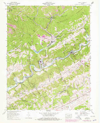
1958 Map of Carbo
USGS Topo · Published 1978About this map
The Clinch River carves a winding path through the heart of Russell County, defining a landscape shaped by coal production and river-valley agriculture. This mid-century survey captures the industrial footprint of the Moss No 3 Preparation Plant and the nearby Clinch River Steam Plant at Carbo, documenting the vital energy infrastructure of the era. Extensive strip mines mark the northern ridges above South Clinchfield, while the rugged southern terrain transitions into the distinct topography of Sinkhole Valley and Reeds Valley. The map is particularly useful for genealogical research, identifying dozens of family burial sites such as the Rasnake Cem, Sutherland Cem, and Musick Cem. Beyond heavy industry, the map records local landmarks like the Jessee Mill and the Norfolk and Western rail lines that once integrated these remote mountain communities with the regional economy.
Find a feature on this map
91 named features on this map. Tap any name to fly to it.
Don’t see what you’re looking for? This feature index may not catch every label — zoom into the map to look around manually.
Map Details
Editions of this 1958 Carbo Map
4 editions found
Other maps of this area

1886 · Grundy
USGS Topo · 1:125,000

1890 · Grundy
USGS Topo · 1:125,000

1892 · Grundy
USGS Topo · 1:125,000

1897 · Bristol
USGS Topo · 1:125,000

1902 · Bristol
USGS Topo · 1:125,000

1913 · Clintwood
USGS Topo · 1:62,500

1914 · Bucu
USGS Topo · 1:48,000

1915 · Clintwood
USGS Topo · 1:62,500

1916 · Bucu
USGS Topo · 1:62,500

1918 · Carterton
USGS Topo · 1:62,500