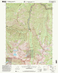
2001 Map of Caribou Lake
USGS Topo · Published 2004About this map
The Salmon Mountains and the Trinity Alps converge in this high-altitude landscape where the Siskiyou Co Trinity Co line divides the terrain. The map documents a rugged interior defined by granite peaks and alpine basins, including the waters of Caribou Lake and Lower Caribou Lake. Human presence is concentrated around historic extraction sites such as the Lower Nash Mine and Yellow Rose Mine, or seasonal outposts like Mountain Meadow Ranch. The Weaverville Salmon River Rd provides the primary transit artery through the wilderness, connecting remote landmarks like Big Flat and Josephine Lake Lodge. This 2001 revision illustrates how the area remained a protected sanctuary within the Klamath National Forest and Trinity National Forest, where high-elevation landmarks like Caribou Mtn and Preachers Peak tower over the South Fork Salmon River and Coffee Creek.
Find a feature on this map
51 named features on this map. Tap any name to fly to it.
Don’t see what you’re looking for? This feature index may not catch every label — zoom into the map to look around manually.
Map Details
Editions of this 2001 Caribou Lake Map
2 editions found
Other maps of this area

1886 · Shasta
USGS Topo · 1:250,000

1890 · Red Bluff
USGS Topo · 1:250,000

1894 · Red Bluff
USGS Topo · 1:250,000

1894 · Shasta
USGS Topo · 1:250,000

1909 · Big Bar
USGS Topo · 1:96,000

1913 · Weaverville
USGS Topo · 1:125,000

1915 · Big Bar and Vicinity
USGS Topo · 1:250,000

1923 · Sawyers Bar
USGS Topo · 1:125,000

1931 · Etna
USGS Topo · 1:96,000

1934 · Etna
USGS Topo · 1:125,000