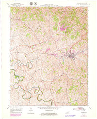
1953 Map of Carlisle
USGS Topo · Published 1979About this map
Carlisle serves as the primary hub in this central Kentucky landscape, situated along the Louisville and Nashville railroad line. The terrain is defined by the winding course of Hinkston Creek and its many tributaries, including Brushy Fork and Big Brushy Creek. This mid-century survey, with updates from the late 1970s, reveals a rural landscape deeply rooted in its agricultural and social institutions. Scattered across the ridges and valleys are essential community anchors such as Oakland Mills Ch, Stony Creek Ch, and Parks Sch.
Find a feature on this map
22 named features on this map. Tap any name to fly to it.
Don’t see what you’re looking for? This feature index may not catch every label — zoom into the map to look around manually.
Map Details
Editions of this 1953 Carlisle Map
2 editions found
Other maps of this area

1952 · Cowan
USGS Topo · 1:24,000

1952 · Sharpsburg
USGS Topo · 1:24,000

1952 · Paris East
USGS Topo · 1:24,000

1952 · North Middletown
USGS Topo · 1:24,000

1952 · Piqua
USGS Topo · 1:24,000

1952 · Shady Nook
USGS Topo · 1:24,000

1953 · Carlisle
USGS Topo · 1:24,000

1953 · Moorefield
USGS Topo · 1:24,000

1953 · Millersburg
USGS Topo · 1:24,000

1956 · Louisville
USGS Topo · 1:250,000