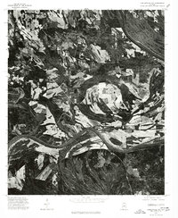
1975 Map of Carlowville NW
USGS Topo · Published 1977About this map
The Alabama River winds through this 1975 orthophoto quadrangle, defining the agricultural and wooded landscape of Dallas County. This aerial perspective, captured in late November, reveals a patchwork of tilled fields, timber tracks, and riverine bends that characterize the Black Belt region. The small settlement of Pinebelt sits near the river's edge, serving as a focal point for the surrounding rural homesteads and farm roads. The high-contrast imagery highlights the distinct geological contours and drainage patterns leading toward the river basin, providing a clear view of land use and property boundaries before more modern development altered the rural layout.
Find a feature on this map
2 named features on this map. Tap any name to fly to it.
Don’t see what you’re looking for? This feature index may not catch every label — zoom into the map to look around manually.
Map Details
Editions of this 1975 Carlowville NW Map
This is the sole edition of this map. No revisions or reprints were ever made.
Other maps of this area

1953 · Montgomery
USGS Topo · 1:250,000

1956 · Montgomery
USGS Topo · 1:250,000

1957 · Montgomery
USGS Topo · 1:250,000

1957 · Carlowville
USGS Topo · 1:62,500

1958 · Selma
USGS Topo · 1:62,500

1968 · Safford
USGS Topo · 1:24,000

1974 · Crumptonia
USGS Topo · 1:24,000
1974 · Camden North
USGS Topo · 1:24,000

1975 · Selma SE
USGS Topo · 1:24,000

1975 · Carlowville NE
USGS Topo · 1:24,000