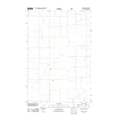
2011 Map of Carlyle
USGS Topo · Published 2011About this map
Carlyle and its surrounding prairie landscape are defined by a network of drainage systems that cross the North Dakota and Montana border. The settlement is centered along Carlyle Rd, where the local community’s history is anchored by the Carlyle Cemetery. The terrain is deeply etched by the wandering paths of Bullion Creek and the East Fork Beaver Creek, which provide essential drainage for this agricultural region. To the north, Johnstone Dam manages local water resources near the intersection of 169th Ave SW and 46th St SW. The map illustrates a strictly organized section-line road grid, including Ollie Rd and Edge Hill Rd E, which dictates the movement and property boundaries of the township. This layout reflects the enduring structure of Great Plains land division, where small drainages like Williams Creek and Lamester Creek serve as the primary natural landmarks in an otherwise geometric landscape.
Find a feature on this map
20 named features on this map. Tap any name to fly to it.
Don’t see what you’re looking for? This feature index may not catch every label — zoom into the map to look around manually.
Map Details
Editions of this 2011 Carlyle Map
This is the sole edition of this map. No revisions or reprints were ever made.
Other maps of this area

1953 · Miles City
USGS Topo · 1:250,000

1953 · Dickinson
USGS Topo · 1:250,000

1957 · Dickinson
USGS Topo · 1:250,000

1957 · Miles City
USGS Topo · 1:250,000

1958 · Miles City
USGS Topo · 1:250,000

1980 · Golva
USGS Topo · 1:24,000

1980 · Thelan
USGS Topo · 1:24,000

1980 · Belfield
USGS Topo · 1:100,000
1981 · Shell Butte
USGS Topo · 1:24,000

1981 · Carlyle
USGS Topo · 1:24,000