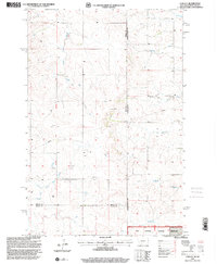
1997 Map of Carlyle
USGS Topo · Published 2001About this map
Carlyle serves as the primary focal point of this late-twentieth-century survey, situated within the drainage patterns of the northern plains. The landscape is defined by the branching tributaries of Bullion Creek and Lame Steer Creek, illustrating the natural watercourses that shaped early ranching and settlement in Wibaux County. Mapping by the U.S. Geological Survey and USDA Forest Service details the intricate terrain along the border with North Dakota, including the western edge of the Little Missouri National Grassland. For local historians and genealogists, the placement of the Cem near the town site provides a specific point of interest for family research. The presence of the Fifteenth Guide Meridian East and various section lines underscores the precise grid system imposed upon this expanse of Snow and grasslands, where infrastructure such as a prominent Pipeline and a Gravel Pit mark the modern industrial footprint.
Find a feature on this map
16 named features on this map. Tap any name to fly to it.
Don’t see what you’re looking for? This feature index may not catch every label — zoom into the map to look around manually.
Map Details
Editions of this 1997 Carlyle Map
This is the sole edition of this map. No revisions or reprints were ever made.
Other maps of this area

1953 · Miles City
USGS Topo · 1:250,000

1953 · Dickinson
USGS Topo · 1:250,000

1957 · Dickinson
USGS Topo · 1:250,000

1957 · Miles City
USGS Topo · 1:250,000

1958 · Miles City
USGS Topo · 1:250,000

1980 · Golva
USGS Topo · 1:24,000

1980 · Thelan
USGS Topo · 1:24,000

1980 · Belfield
USGS Topo · 1:100,000
1981 · Shell Butte
USGS Topo · 1:24,000

1981 · Carlyle
USGS Topo · 1:24,000