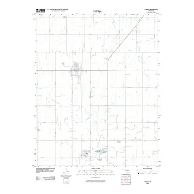
2009 Map of Carmen
USGS Topo · Published 2009About this map
Carmen and Aline anchor this central Oklahoma landscape, where the grid of the High Plains meets a complex network of oil production and prairie waterways. The town of Carmen is organized around a distinct street grid, while the smaller settlement of Aline sits to the south near the banks of Eagle Chief Creek. This region of Alfalfa County is defined by its agricultural layout and energy resources, notably the South Carmen Oil Field and the Ringwood Oil Field. Five different burial grounds, including Pleasant Ridge Cemetery and Eastern Star Cemetery, are scattered across the quadrangle, serving as vital records for local genealogical research. In the southern portion of the sheet, the landscape is punctuated by the Big Timber Lakes West and Big Timber Lakes East, created by the Big Timber Lakes West Dam and Big Timber Lakes East Dam, which disrupt the seasonal flow of Spring Creek.
Find a feature on this map
35 named features on this map. Tap any name to fly to it.
Don’t see what you’re looking for? This feature index may not catch every label — zoom into the map to look around manually.
Map Details
Editions of this 2009 Carmen Map
This is the sole edition of this map. No revisions or reprints were ever made.
Other maps of this area

1955 · Woodward
USGS Topo · 1:250,000

1958 · Woodward
USGS Topo · 1:250,000

1968 · Carmen
USGS Topo · 1:24,000

1969 · Dacoma
USGS Topo · 1:24,000

1969 · Lambert
USGS Topo · 1:24,000

1969 · Fairview NE
USGS Topo · 1:24,000

1969 · Helena
USGS Topo · 1:24,000

1969 · Cleo Springs
USGS Topo · 1:24,000

1969 · Glass Mountains NE
USGS Topo · 1:24,000
1969 · Dacoma SE
USGS Topo · 1:24,000