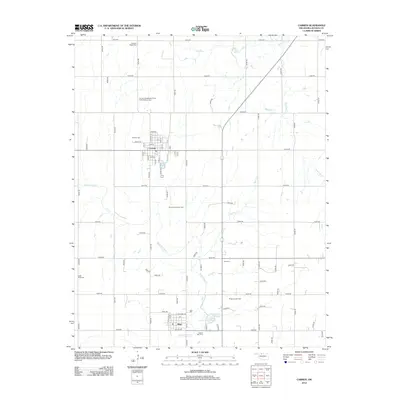
2012 Map of Carmen
USGS Topo · Published 2012About this map
Carmen and Aline anchor this Alfalfa County landscape, where the agricultural grid is deeply intertwined with the region's energy and community history. The map highlights a remarkable concentration of fraternal and community burial grounds, including the Carmen Independent Order of Odd Fellows Cem and the Eastern Star Cem, reflecting the social fabric of early 20th-century settlement. Between these small hubs, the South Carmen Oil Field and Ringwood Oil Field indicate the ongoing role of the petroleum industry in the local economy. Waterways like Eagle Chief Cr and Spring Cr cut across the section lines, leading toward the Big Timber Lakes E and Big Timber Lakes W in the south, providing a natural contrast to the structured road network of E0270 RD and N2530 RD.
Find a feature on this map
78 named features on this map. Tap any name to fly to it.
Don’t see what you’re looking for? This feature index may not catch every label — zoom into the map to look around manually.
Map Details
Editions of this 2012 Carmen Map
This is the sole edition of this map. No revisions or reprints were ever made.
Other maps of this area

1955 · Woodward
USGS Topo · 1:250,000

1958 · Woodward
USGS Topo · 1:250,000

1968 · Carmen
USGS Topo · 1:24,000

1969 · Dacoma
USGS Topo · 1:24,000

1969 · Lambert
USGS Topo · 1:24,000

1969 · Fairview NE
USGS Topo · 1:24,000

1969 · Helena
USGS Topo · 1:24,000

1969 · Cleo Springs
USGS Topo · 1:24,000

1969 · Glass Mountains NE
USGS Topo · 1:24,000
1969 · Dacoma SE
USGS Topo · 1:24,000